We had an average of two people pass by on this road each day. Just the type of seclusion we seek. Every night packs of coyotes would run by our spot, yelping in that other-worldly way that packs of coyotes yelp.
And we took four great hikes.
One day we followed some roads to a spot where we thought we could tie into a trail called the General George Crook National Recreation Tail. So we headed across country to see if we could find it.
It was interesting. On one of our maps it was called the "Strawberry Road." There is town of Strawberry some 5 or so miles away, and maybe 100 years ago this road was what people took to go from Camp Verde to Strawberry. Who knows.
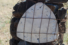
The road was easy to follow for about 1 mile, but then it simply disappeared into the prairie. We could see where the trail used to be because years ago someone had built cairns, although the signs on the cairns were almost all faded away. If you look carefully you can see the wording on the sign. There were also some "straight lines" made of rocks, marking the two sides of the trail, and one of our principles for investigating nature is that "there are no straight lines in nature." So we knew we were on the road from that.
The trail had clearly not been walked on for many years. No footprints, and the grass had grown all over it:
The trail is so little used that at one point a fence had been installed right over it. Can you believe that? We had to crawl under the fence to continue on it.
We did some digging and found that this road/trail was in use until 1928, almost 100 years ago. This is from a website about the road/trail:
In 1871, General George Crook came to Arizona Territory as Commander of the Department of Arizona. His orders were to subdue the Indians of the Territory and place them on reservations. General Crook realized at once that in order to accomplish this goal he must be able to move troops and supplies into the haunts of the Indians with swiftness and surprise.
In August of that year, General Crook left Fort Apache with a unit of cavalry troops to locate and mark a supply road from Fort Apache to Fort Whipple in Prescott. As they moved westerly across the Mogollon Rim, then called Black Mesa, Crook realized quickly that he must stay close to the edge of the escarpment, otherwise, when he moved north, he encountered deep and rugged canyons. It was rough going but the trekkers found water in small lakes. Crook pushed on, and in early September of 1871, he reached Fort Whipple in Prescott. Actual construction of a road started in the spring of 1872. By 1873, supplies began moving by pack train from Fort Verde to Fort Apache. One year later in September 1874, the first wagon supply train left Fort Whipple for Fort Apache.
Martha Summerhayes, the first woman to travel over the road, was on that trip. She later wrote the book, Vanished Arizona, telling of her experiences on the road and describing her travels in Arizona Territory.
During the next 22 years, Crook Road was used by troops patrolling across the Territory and the northern boundary of the Apache Reservation. The road was in continual use for 32 more years, until the Rim Road was built in 1928.
When we got closer to the camper we left the "trail" and headed toward it. You have to look carefully in the photo, but you'll see us!
OK. This trail is a National Historic Trail. And it is wonderful. General Crook was an important historic figure in the old west. This part of our history is being lost. This trail is neglected. It is sad and it is wrong.


No comments:
Post a Comment